Export Tool - Configuration
The Export Tool is configured in this section. In the finished app, the Export Tool can be accessed via the export icon in the toolbox. The functionality of the Export Tool in the app is described here.
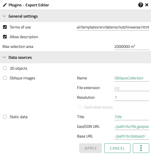
Clicking on opens the configuration window, which shows the available configuration.

General Settings
| Option | Description |
|---|---|
Terms of use |
Allows the reference to the terms of use of the data or data protection notice |
Allow description |
Allows the user to create a description of the data to be downloaded |
Max selection area |
Limits the selection area that can be created to a certain value |
Data sources
3D objects

| Option | Description |
|---|---|
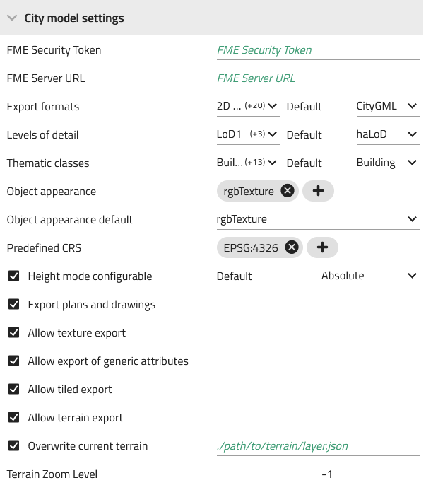
FME Security Token |
FME Security Token |
FME Server URL |
URL to the FME server that is to be used for processing, e.g. https://<fmeserverhost>/fmedatadownload/<Reporsitory>/<workspaceName>.fmw |
Export formats |
Selection of export formats to be made available (multiple selection possible) |
Levels of detail |
Selection of the LODs (Levels of Detail) that are to be made available for export |
Thematic classes |
Selection of the thematic classes that are to be made available for export |
Object appearance |
Selection of the object texture(s) to be made available for export |
Object appearance default |
A default texture can be specified here that is to be preset when activating the export tool. |
Predefined CRS |
The EPSG code of the coordinate reference system in which the data is to be exported |
Height mode configurable |
Allows the user to select the elevation mode the data is to be exported in |
Export plans and drawings |
If this option is active, the entire visible scene including plans, drawings and vector layers is exported during an export. If it is inactive, only the content of the database is made available for export. |
Allow texture export |
Allows the user to export object textures |
Allow export of generic attributes |
Allows the user to add generic attributes to the export |
Allow tiled export |
Allows the user to export the desired objects tiled |
Allow terrain export |
If this option is active, the user can also export the terrain currently displayed in the 3D view. |
Overwrite current terrain |
The path to an alternative terrain file can be specified here, which can then be exported instead of the currently active terrain. |
Terrain Zoom Level |
A different terrain zoom level reduces the resolution of the terrain, which results in lower CPU utilisation during download. The higher the number, the smaller the mesh triangles, while -1 is the maximum resolution. |
Oblique images

| Option | Description |
|---|---|
Name |
The name of the oblique image layer to be provided for export |
File extension |
The file format of the oblique images |
Resolution |
The resolution of the oblique images |
Dedicated source |
The URL of the image source can be entered here. |
Static data

| Option | Description |
|---|---|
Title |
Specification of the title that appears in the selection list of the export tool |
GeoJSON URL |
URL of the GeoJSON file containing the polygons of the models and the filename.zip |
Base URL |
URL to the directory (web server) from which the file is to be downloaded, |
| Apply applies the changes made to the displayed app. See also Editing and Saving |