Vektor Cluster Groups
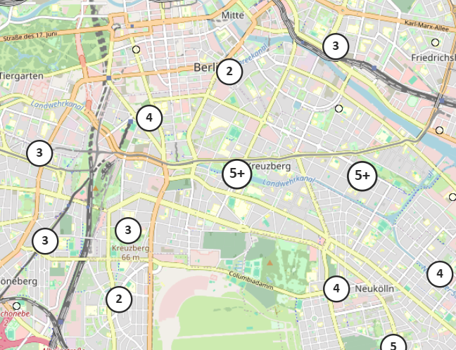
Vector Cluster Groups allow multiple point features to be grouped together, optimizing the visualization of large datasets. Isolated points remain unchanged, while overlapping or closely positioned points are combined into a cluster. Clicking on a cluster displays a list of the original point features it contains.
To use clustering, at least one Vector Cluster Group must be created. In the Handling in map section, it can be configured whether a Vector Cluster Group is used for vector layers and which specific group is applied.
A Vector Cluster Group can be configured with the following settings:
General Settings
| Option | Description |
|---|---|
Name (ID) |
Unique name (identifier) of the created Vector Cluster Group. |
Distance |
The minimum pixel distance at which nearby points are grouped into a cluster. |
Handling in map
| Option | Description |
|---|---|
Z-Index |
The z-index determines the display order. If one layer has a higher value relative to another, it overlaps them in the display. |
Vector properties
| Option | Descripton |
|---|---|
Altitude mode |
Defines the height mode used. 'Drape on terrain' places 2D data on the terrain. 'Relative to terrain' interprets heights as values above the terrain. 'Absolute' is the 3D elevation above the reference ellipsoid. |
Height above ground |
A vertical offset to the terrain. Can be used with altitude mode 'Relative to terrain'. |
Ground level |
Ground height level of the objects. |
Scale by distance |
Gets or sets near and far scaling properties of objects based on the object’s distance from the camera. Interpolation of the objects scale between the provided distances. Outside of these ranges the object’s scale remains clamped to the nearest bound. If unchecked, no scaling is applied. |
Eye offset |
Gets or sets the 3D Cartesian offset applied to objects in eye coordinates. Eye coordinates is a left-handed coordinate system, where x points towards the viewer’s right, y points up, and z points into the screen. Eye coordinates use the same scale as world coordinates, which is typically meters. An eye offset is commonly used to arrange multiple billboards or objects at the same position, for example to arrange a billboard above its corresponding 3D model. |
Allow picking |
Defines if the features are pickable, for example for enabling Feature Info. |
Display
By default, clusters scale up when selected. This behavior can be modified using the setting 'Highlight style'. The Default Style and Selection Style options can only be adjusted if the corresponding checkbox is enabled.
| Option | Description |
|---|---|
Template |
Allows customization of the cluster’s appearance, such as color or font style. |
Breaks |
Defines how many points are displayed before a cluster switches to the 'Number+' format. |
Zero scale offset |
Specifies at which step the cluster icons start to scale up. A value of 0 causes scaling to begin at the second step. |
Scale factor |
Defines how much the cluster icons increase in size as the number of points within the cluster grows. |