Show side map
Clicking on the Show side map button in the toolbar activates a second map area parallel to the currently active map, which can be used to display a side map. The drop-down menu at the top of the side map defines which additional map is opened.

The side map is used exclusively as a secondary view. For example, the 2D map can provide supplementary information from a second perspective when the 3D map or panorama map is the main view. However, it does not support the full range of functions of the main map, such as layer control or the use of tools. Only selected click interactions are supported (e.g., to control panorama navigation in the main map).
| The content window, the tools in the toolbar, and the map navigation always refer to the main map. |
When the mouse is moved over the vertical dividing line between the main map and the side map, an ![]() icon appears. This allows the size of the side map to be adjusted, although a predefined minimum and maximum width must be respected.
icon appears. This allows the size of the side map to be adjusted, although a predefined minimum and maximum width must be respected.
Clicking on again closes the side map.
Synchronize views
When the side map is opened, the button is active by default and the current position and, if applicable, the perspective of the main map is automatically transferred to the side map with each change. Conversely, the position and view of the side map can be changed independently of the main map. Changing the position or perspective of the main map again synchronizes both map views with each other.
If this behavior is not desired, this functionality can be temporarily deactivated by clicking on the button .
|
Exception: Panorama map
If the panorama map is selected as the side map, synchronization is automatically deactivated, as even slight changes in position or perspective can trigger unwanted image changes. Instead, when the side map is open, the panorama is displayed directly there when a panorama location is selected in the main map – switching the main map will be omitted. If necessary, synchronization can be activated at any time, e.g., for a direct comparison of 3D and panorama views. For this purpose, it is particularly useful to first activate pedestrian mode in 3D beforehand to avoid unwanted position changes and only synchronize the viewing direction. |
Switch views
The content window, tools, and map navigation of VC Map always refer to the main map and are not applicable to the side map. The main map (highlighted in the map control bar) is the active working view in which all interactions and functions are available. To make the side map the main map and thus fully controllable, use the button .
Clicking this button swaps the two views:
-
The previous side map becomes the main map.
-
The previous main map becomes the side map.
This allows the desired map to be actively edited and controlled. Clicking again restores the original assignment.
Special case: Oblique-Multiview
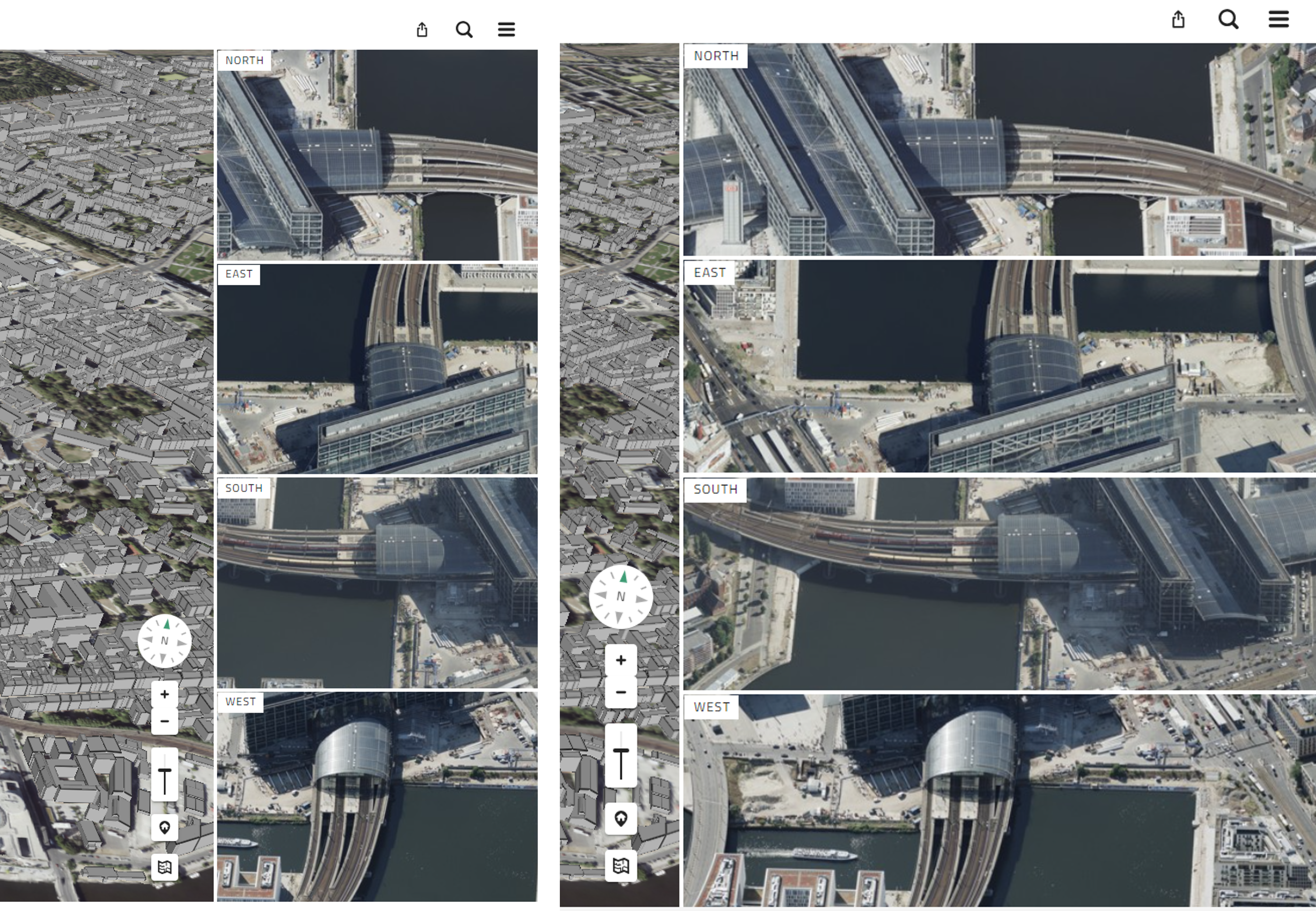
The oblique aerial image multiple view displays the corresponding oblique aerial images from all four cardinal directions in the side map, synchronized with the map view of the main map.
The main map is displayed on the left according to the active selection in the map area (3D, 2D, oblique aerial image, or panorama), and the four corresponding oblique aerial images are displayed on the right according to the current position of the main map. The cardinal direction that corresponds to the viewing direction of the main map is highlighted in color in the multiple view.

When moving or zooming in the main map, the views in the oblique multiview change synchronously, provided that the button is active.
By clicking on the button that names the cardinal direction in the multiple view, the main map is rotated in the respective viewing direction (with the exception of the 2D map, which is always oriented to the north).