General Functions
Theme map selection
The theme map selector opens a selection window, which provides various thematic map modules. This thematic content can add or replace maps, map content or -functions to the application. Depending on the individual configuration of the VC Map App, it may be necessary to select a module when starting the application in order to load different map content according to the user input.

The available themes are offered via various image cards. Only one map theme can be added to an existing application at a time. To change the theme of the application again, the theme map selector can be opened again to select a different theme.
Themes can be organized in groups. A group node appears as a stack of image cards in the theme map selection. If a group node is selected, the subordinate theme selection opens in the same window. The first image card Back can be used to navigate back to the start view.
Depending on the configuration of the application, the theme map selection can provide a base module. This is displayed as the first image card and is highlighted in color. The base module, if available, is always preselected and cannot be removed from the selection. The application may already be started with the base module only.
If a description is stored for a theme, an is displayed on the corresponding image card. On hover the description is shown as a tooltip.
Share
The Share tool provides several ways to share a particular map view from the application with other users.
| Action | ..UI |
|---|---|
Copy link • the view on the 3D scene |
|
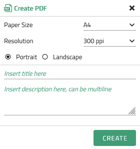
Create PDF The desired resolution, orientation and paper format can be selected, and a title and description can be added.
|
|
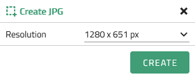
Create JPG
|
Search
The search tool enables, depending on the configuration of the search provider, address-/POI- and/or coordinate searches. This makes it easy to navigate to known addresses or points of interest on the map.
-
The address and POI search can be used to search for addresses or keywords (depending on the search provider used in the respective app). The search field can support this by providing suggestions (e.g. keywords, company and street names) to complete the search query.
-
The coordinate search allows you to search using coordinate pairs. All VC Maps that have integrated the coordinate search as a search provider support a search using WGS84 coordinates with the syntax
<Lon>, <Lat>in decimal degrees. Example for the coordinate search using WGS84 coordinates:13.339138, 52.503497.
The support of other reference systems depends on the configuration of this search option in the map and can also include the search using projected coordinates, in this case the search is carried out according to the syntax<easting>, <northing>. Example for the coordinate search using EPSG:25833 coordinates:387268.611, 5818337.466.
Menu
The menu contains options to customize the map application.
| Setting | Description |
|---|---|
Language setting |
Here the user can change the language of the application, by selection in the dropdown menu. In the basic configuration German (de) and English (en) are available. Depending on the application and individual configuration, other languages may also be listed here. |
Display Settings |
Allows to change the display quality. Available quality levels are: |
Color scheme |
This option allows the user to customize the color scheme used by the application. Currently, the light and dark color schemes are available for selection. The default color scheme adapts to the browser settings. Depending on the selection, the window colors, hover and selection colors are changed with the corresponding selection. |
Filters and effects |
In this section you can find the settings for filters and effects that can be applied to the map view. In addition, there is the possibility to make adjustments to ambient occlusion, bloom, depth of field, black/white filters, brightness, silhouette, blur, night view, HDR (High Dynamic Range) and lighting. |

