Feature Module
The Feature module defines the tables for storing city objects, including their attributes and relationships with other features, geometries, and appearances. It provides a streamlined yet powerful framework capable of representing all city objects defined in CityGML.
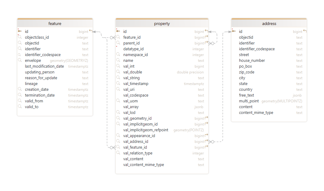
FEATURE table
The FEATURE table is the central table in the VCDB v5 relational schema. It serves as the primary storage for
all city objects and uniquely identifiable entities such as buildings, roads, or vegetation objects within
your city model.
Each feature is assigned a unique id as the primary key. The objectid is a string identifier used to uniquely
reference a feature within the database and datasets. It is recommended to use a globally unique value for objectid and ensure
this column is always populated. The identifier column provides an optional identifier to uniquely distinguish the
feature across different systems and potentially multiple versions of the same real-world object. It must be
accompanied by a code space, stored in the identifier_codespace column, which indicates the authority responsible for
maintaining the identifier.
The objectclass_id enforces the type of the feature, such as building, window, city furniture, or tree. It serves as a
foreign key to the OBJECTCLASS table, which lists
all feature types supported by the VCDB instance.
The bi-temporal timestamp pairs creation_date and termination_date, along with valid_from and valid_to, enable
the management of feature history. The creation_date and termination_date refer to database time, indicating when
the feature was inserted or terminated in the database, while valid_from and valid_to define the feature’s lifespan
in the real world. The creation_date shall be automatically populated when the feature is first imported into the
VCDB, unless the input dataset already contains a value. The termination_date can be used as a flag to indicate that a
feature version is no longer active, without physically deleting the feature from the database.
The columns last_modification_date, updating_person, reason_for_update, and lineage are specific to VCDB and
are not defined in CityGML. These metadata fields capture details about the feature’s origin, its update history, the person
responsible for changes, and the reasons behind those updates.
The spatial envelope column stores the minimal 3D rectangle that encloses the features. This column can be
used for efficient spatial queries of features.
PROPERTY table
The PROPERTY table is the central place for storing feature properties in the VCDB. Each property is recorded with
its name, namespace, data type, and value. This design ensures flexibility and extensibility, allowing the addition of
new properties without schema changes. Properties can represent attributes or relationships linking features,
geometries, and appearances.
|
Which properties are available for a given feature?
As described above, each feature must be assigned a feature type from the
|
The property’s name and namespace are stored in the name and namespace_id columns, respectively. The
namespace_id is a foreign key referencing a namespace from the NAMESPACE
table. Properties are linked to their owning feature via feature_id, which points to the FEATURE table.
The datatype_id column enforces the property’s data type and uses a type definition in the
DATATYPE table. The value of the property is stored in one or more val_*
columns, depending on its data type.
Simple and complex attributes
Simple attribute values such as integers, doubles, strings, or timestamps are stored in the corresponding val_int,
val_double, val_string, or val_timestamp columns. Boolean values are stored in the val_int column, with 0
representing false and 1 representing true. Array values of attributes are represented as JSON arrays in the
val_array column, with items that can either be simple values, JSON objects, or JSON arrays themselves.
The val_content column can hold arbitrary content as a character blob, while the val_content_mime_type column
specifies the MIME type of the content. This setup can be used to store property values in the format they appear in the original
input datasets (e.g., GML/XML or JSON).
The PROPERTY table also supports complex attributes, which may include both a simple value and nested attributes
of either simple or complex types. When the value and the nested attributes can be represented using multiple val_*
columns, the entire complex attribute can still be stored in a single row. For example, a measurement with a unit can
be stored with the value in the val_double column and the unit in the val_uom column.
When complex types cannot be captured in a single row, they are instead represented hierarchically within the
PROPERTY table. Nested attributes reference their parent attribute through the parent_id foreign key, which links
to the id primary key of the parent property. This structure enables the representation of hierarchies with arbitrary
depth.
Relationships
In addition to attributes, the PROPERTY table stores relationships that define how a feature is connected to other
objects. These relationships are stored as separate rows and are not mixed with attribute values in the same row.
Relationships to other features are represented by the feature_id column, linking to related features in
the FEATURE table. The val_relation_type defines the type of the feature relationship as an integer:
-
0for "relates" (a general association between features), and -
1for "contains" (a subfeature relationship, where the referenced feature is considered a part of the parent feature).
| The relation type has specific implications. For example, "contained" features are deleted along with their parent features, while "related" features are not (see delete functions). |
Geometries are linked to features through the val_geometry_id column, which references the
GEOMETRY_DATA table. The optional val_lod indicates the Level of Detail (LoD) of the geometry.
Implicit geometries are referenced via the val_implicitgeom_id foreign key and are also stored in the
GEOMETRY_DATA table. In addition to val_lod, the
transformation matrix and reference point needed to define the feature’s implicit representation are stored in
val_array and val_implicitgeom_refpoint.
Appearance and address information are linked using the val_appearance_id and val_address_id foreign keys,
referencing the APPEARANCE and ADDRESS tables.
Examples
|
In which columns do you store or look up property values?
The |
To demonstrate how feature properties are stored in the PROPERTY table based on their data type, let’s use the name
attribute of city objects as an example. The name attribute is of type core:Code, with a value that is a
string-based term and an optional codeSpace attribute. The JSON type definition from the DATATYPE
table is as follows:
{
  "identifier": "core:Code",
  "description": "Code is a basic type for a string-based term, keyword, or name that can additionally have a code space.",
  "table": "property",
  "value": {
    "column": "val_string",
    "type": "string"
  },
  "properties": [
    {
      "name": "codeSpace",
      "namespace": "http://3dcitydb.org/3dcitydb/core/5.0",
      "description": "Specifies the code space of the term, typically a dictionary, thesaurus, classification scheme, authority, or pattern for the term.",
      "value": {
        "column": "val_codespace",
        "type": "string"
      }
    }
  ]
}
Based on this definition, the core:Code value is stored as a string in the val_string column, while the nested
codeSpace attribute, also a string, is mapped to the val_codespace column. Since the type definition does not
require linking the codeSpace via parent_id, both values are stored within the same row, as shown below. Note that
all other PROPERTY columns have been omitted for brevity.
| id | name | parent_id | val_string | val_codespace | … |
|---|---|---|---|---|---|
1 |
"name" |
|
"myBuilding" |
"https://example.org/buildings" |
… |
The height of CityGML buildings can be represented using the con:Height
data type, which serves as example of a more complex type. The JSON type definition for this data type in the DATATYPE
table is shown below:
-
con:Height -
core:Measure -
core:String
{
  "identifier": "con:Height",
  "description": "Height represents a vertical distance (measured or estimated) between a low reference and a high reference.",
  "table": "property",
  "value": {
    "property": 0
  },
  "properties": [
    {
      "name": "value",
      "namespace": "http://3dcitydb.org/3dcitydb/construction/5.0",
      "description": "Specifies the value of the height above or below ground.",
      "type": "core:Measure",
      "join": {
        "table": "property",
        "fromColumn": "id",
        "toColumn": "parent_id"
      }
    },
    {
      "name": "status",
      "namespace": "http://3dcitydb.org/3dcitydb/construction/5.0",
      "description": "Indicates the way the height has been captured.",
      "type": "core:String",
      "join": {
        "table": "property",
        "fromColumn": "id",
        "toColumn": "parent_id"
      }
    },
    {
      "name": "lowReference",
      "namespace": "http://3dcitydb.org/3dcitydb/construction/5.0",
      "description": "Indicates the low point used to calculate the value of the height.",
      "type": "core:Code",
      "join": {
        "table": "property",
        "fromColumn": "id",
        "toColumn": "parent_id"
      }
    },
    {
      "name": "highReference",
      "namespace": "http://3dcitydb.org/3dcitydb/construction/5.0",
      "description": "Indicates the high point used to calculate the value of the height.",
      "type": "core:Code",
      "join": {
        "table": "property",
        "fromColumn": "id",
        "toColumn": "parent_id"
      }
    }
  ]
}
{
"identifier": "core:Measure",
"description": "Measure is a basic type that represents an amount encoded as double value with a unit of measurement.",
"table": "property",
"value": {
"column": "val_double",
"type": "double"
},
"properties": [
{
"name": "uom",
"namespace": "http://3dcitydb.org/3dcitydb/core/5.0",
"description": "Specifies the unit of measurement of the amount.",
"value": {
"column": "val_uom",
"type": "string"
}
}
]
}{
"identifier": "core:String",
"description": "String is a basic type that represents a sequence of characters.",
"table": "property",
"value": {
"column": "val_string",
"type": "string"
}
}This type definition specifies that con:Height has four nested attributes:
-
"value"of typecore:Measure: Represents a measurement, with the value stored inval_doubleand the unit inval_uom. -
"status"of typecore:String: A simple string stored inval_string. -
"lowReference"of typecore:Code: As explained earlier, a string stored inval_string, with the code space stored inval_codespace. -
"highReference"of typecore:Code: Stored the same way aslowReference.
Additionally, the JSON defines a "join" property for each nested attribute that links back to the parent
attribute through the parent_id foreign key. This establishes a hierarchical relationship and means that
each nested attribute should be stored in a separate row, all referencing the same parent id. Since con:Height
does not store an own "value", the parent row will have NULL in all val_* columns.
| id | name | parent_id | val_string | val_double | val_uom | val_codespace | … |
|---|---|---|---|---|---|---|---|
1 |
"height" |
|
|
|
|
|
… |
2 |
"value" |
1 |
|
11.0 |
"m" |
|
… |
3 |
"status" |
1 |
"measured" |
|
|
|
… |
4 |
"lowReference" |
1 |
"lowestGroundPoint" |
|
|
"https://references.org/heights" |
… |
5 |
"highReference" |
1 |
"highestRoofEdge" |
|
|
"https://references.org/heights" |
… |
ADDRESS table
Although Address is a feature type
in CityGML, it is not stored in the FEATURE table. Instead, it is mapped to a dedicated ADDRESS table in
the VCDB relational schema. Address data is valuable in its own right and serves as foundation for specialized
location services. Storing addresses in a separate table enables more efficient indexing, querying, and updates
without impacting the FEATURE table, which may contain a large number of city objects and spatial features.
The columns objectid, identifier, and identifier_codespace in the ADDRESS table are used to store unique identifiers for
an address object, serving the same purpose as in the FEATURE table, as explained above. Address information is
then mapped to the following dedicated columns:
| Column | Description |
|---|---|
|
Holds the name of the street or road where the address is located. |
|
Stores the building or house number. |
|
Stores the post office box number associated with the address, if applicable. |
|
Holds the postal or ZIP code, helping to define the location more precisely. |
|
Stores the name of the city or locality. |
|
Contains the name of the state, province, or region. |
|
Stores the name of the country in which the address resides. |
|
Allows the storage of address information as unstructured text. It can be used to supplement or replace the other structured fields. |
|
Stores the geolocation of an address as multi-point geometry, enabling efficient spatial queries and reverse location services. |
Together, these columns provide a comprehensive and flexible structure for storing address data in a variety of
formats and contexts. However, if the original address information is more complex and needs to be preserved, the
content column can be used to store the address data in its original format as a character blob, with the
content_mime_type column specifying the MIME type of the content.
| The multi-point geometry of an address must be provided in the same Coordinate Reference System (CRS) as defined for your entire VCDB instance. |